
Industries Utilizing Drones
Where are drones being used today?
An increasing number of businesses are turning to drones for help.
Drones are one of today’s most versatile technologies, reshaping how work gets done across the globe. From agriculture to real estate and construction to utilities, drones are helping industries improve efficiency, safety, and accuracy while unlocking new possibilities that weren’t feasible before. Scroll down for a quick a look at how drones are being used.
Here are some of the industries utilizing drones today:
Residential Services
Construction
Development
Agriculture
Search & Rescue
Land Use Planning
Forestry & Conservation
Residential Real Estate
Commercial Real Estate
Property Management
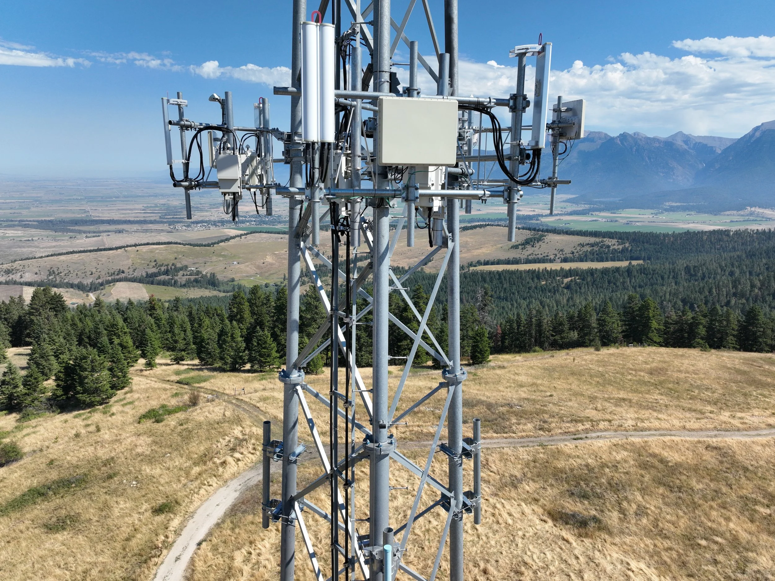
Telecommunications
Utilities
Energy
Mining & Quarries
Media Production
Marketing
Insurance
Archaeology

Residential Services
Across the nation, drones are making home inspections safer and faster by documenting roofs, gutters, siding, and storm damage without risky ladder climbs. Homeowners, contractors, and insurance adjusters use aerial imagery to evaluate hail or wind damage, check for leaks, and document property conditions over time. This approach reduces costs, speeds up claims, and avoids unnecessary risks for workers.
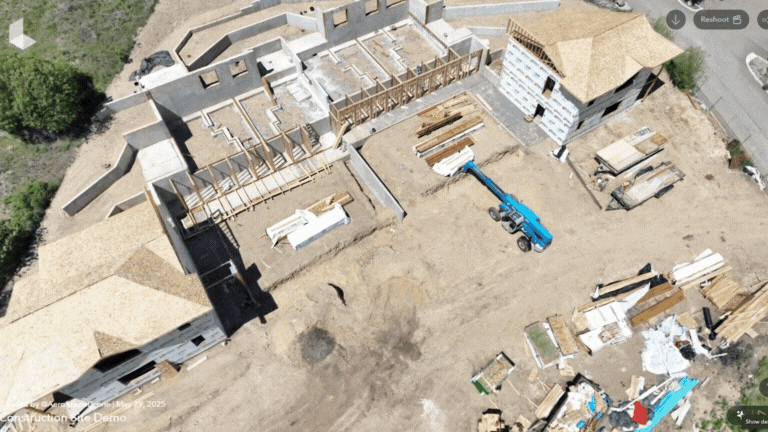
Construction
Construction sites around the world now rely on drones for progress tracking, surveying, and verifying earthworks. Regular aerial reports document installation, keep projects on schedule, reduce costly rework, and improve communication between contractors, architects, and investors. Drones can also identify safety hazards on-site, monitor equipment usage, and create maps and 3D models for project planning and safety briefings.
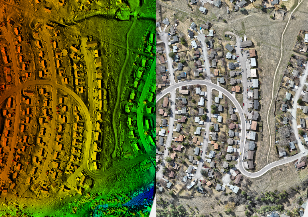
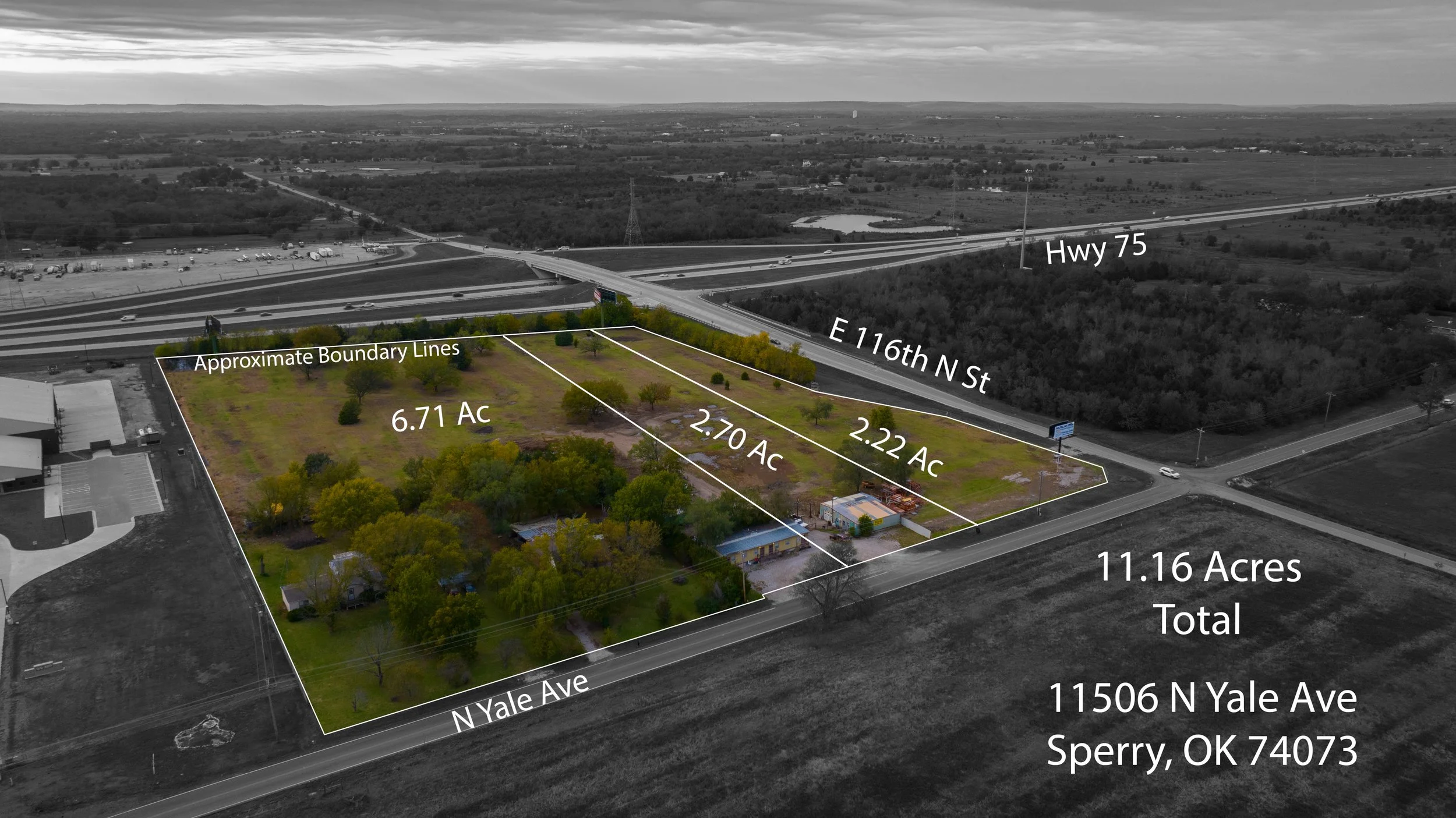
Development
From urban planning in rapidly growing cities to infrastructure projects in rural regions, drones provide accurate 3D mapping and site analysis. Developers use this data to evaluate terrain, identify drainage issues, and design layouts for subdivisions, highways, and commercial zones. Drones are critical tools for initial planning, updating stakeholders, documenting progress, reducing delays and planning more sustainable developments.

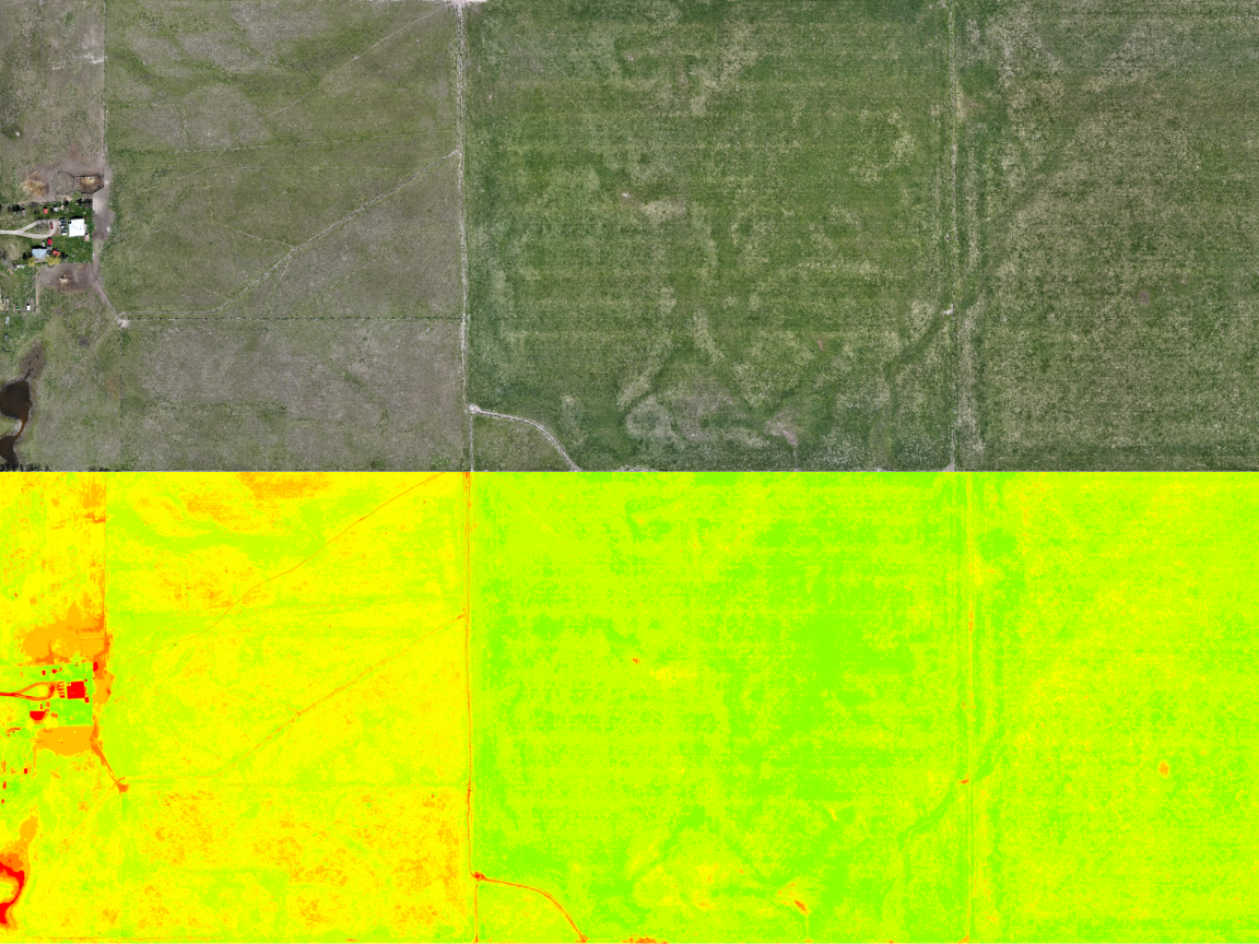
Agriculture
Drones are a global game-changer for agriculture, used in everything from monitoring corn and soybean fields in the U.S. Midwest to managing vineyards in France and rice fields in Asia. Multispectral imaging helps farmers detect crop stress early, optimize irrigation, and monitor nutrient levels. Drones can also be used to plant seeds as well as deliver fertilizers, herbicides, pesticides and fungicides, increasing yields while reducing labor costs.
Search & Rescue
Emergency responders worldwide deploy drones equipped with thermal cameras to find missing persons in forests, mountains, deserts, and disaster zones. In countries like Japan and the U.S., drones have cut search times dramatically by covering terrain that would take ground teams hours or even days. They are also being used after earthquakes and floods to locate survivors and deliver essential supplies to areas that are otherwise unreachable.
Land Use Planning
Governments and planning agencies are using drone-generated maps to make informed decisions about zoning, infrastructure, and environmental protection. In Canada and Europe, drones are being deployed to map wetlands, monitor urban sprawl, and evaluate floodplain risks. This aerial data supports sustainable growth, reduces survey times, and provides planners with an up-to-date perspective.
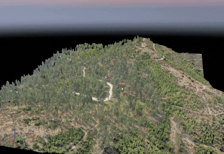
Forestry & Conservation
Forestry services use drones to monitor forest health, measure stand density, and track deforestation. In wildfire-prone regions, drones play a key role in fire line planning, hotspot detection, and post-burn analysis. Beyond wildfire management, drones are also being used for reforestation efforts, pest and disease detection, and long-term monitoring of ecosystem changes.
Residential Real Estate
Realtors across North America, Europe, and Asia use drones to showcase properties with sweeping aerial shots, highlighting neighborhoods, landscapes, and curb appeal. Beyond high-end homes, drones are now used for rental listings, HOA marketing, and even property appraisals. By giving buyers a better sense of scale and location, aerial visuals are raising the standard for real estate marketing worldwide.
Commercial Real Estate
Large commercial developments are leveraging drones for both marketing and planning. High-rise projects, shopping centers, industrial parks, and business campuses benefit from aerial perspectives that highlight scale, accessibility, and nearby infrastructure. Investors and tenants alike gain a better understanding of property value and growth potential.

Property Management
Across the U.S. and Europe, property managers use drones to inspect roofs, facades, parking structures, and large campuses without disruptive scaffolding or lifts. Routine aerial checks help identify wear and tear before it escalates into major repairs. Property managers of resorts, stadiums, and apartment complexes also use drones to monitor grounds, track landscaping, and improve overall asset management.
Telecommunications
Telecom companies worldwide are replacing risky tower climbs with drone inspections. From the U.S. to India, drones are used to monitor cell towers, antennas, and 5G equipment. They can quickly capture high-resolution imagery of hard-to-reach components, reducing downtime, improving safety, and minimizing costly service interruptions.
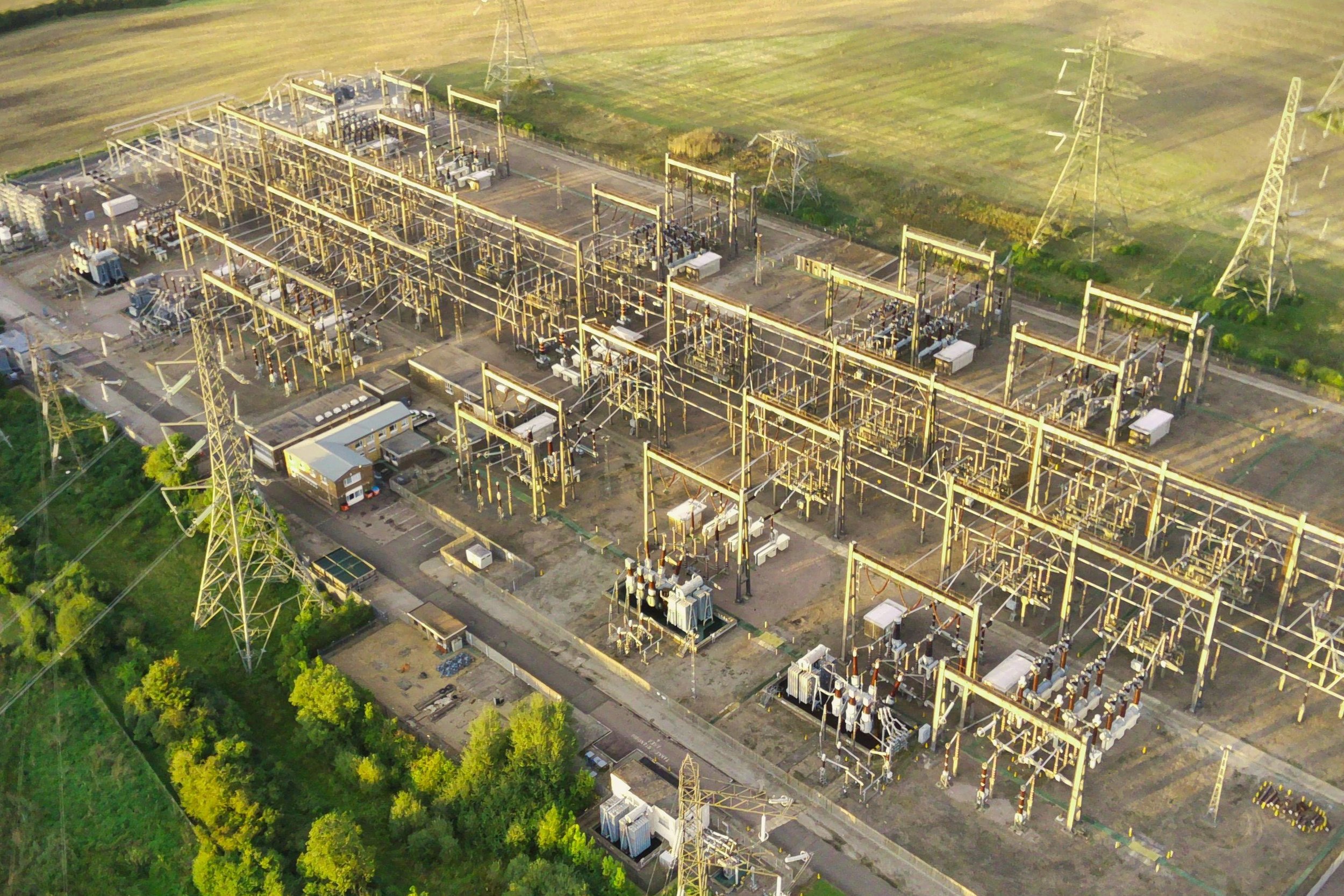
Utilities
Power and energy companies use drones to inspect transmission lines, wind turbines, substations, and pipelines. In Germany, utilities have drastically reduced inspection times by replacing helicopter surveys with drones. In the U.S., drones are deployed after hurricanes and ice storms to identify damaged lines quickly, helping restore service faster and safer than traditional ground inspections.
Energy
Drones are becoming an essential tool in the energy sector, helping companies monitor and maintain critical infrastructure. They are used to inspect oil and gas pipelines, solar farms, and wind turbines—often in remote or hard-to-reach areas. Thermal imaging helps identify faulty solar panels, while aerial inspections of turbines and transmission lines reduce downtime and keep workers out of hazardous environments. By capturing detailed visual data quickly and safely, drones are improving efficiency and reliability across the energy industry.
Mining & Quarries
Mining operations around the world rely on drones for stockpile measurements, blast planning, and safety inspections. Aerial data is quicker and more accurate than manual surveys, allowing teams to measure volumes, monitor slope stability, and reduce the risk of accidents. Drones also help operators track environmental compliance and manage large, rugged sites with fewer resources. Quarries and Landscape companies can easily keep track of material quantities with volume reports.
Media Production
From Hollywood films to global sporting events, drones are revolutionizing cinematography. Productions in Europe, Asia, and the Americas use drones to capture dynamic aerial shots once only possible with helicopters. Weddings, concerts, and corporate events are also incorporating drones to create cinematic highlight reels and immersive marketing content.
Marketing
Worldwide, brands are embracing drone footage for advertisements, tourism campaigns, and product launches. Aerial visuals are now standard for showcasing resorts, golf courses, universities, and automotive commercials. Social media marketers also leverage drone content to stand out with dramatic, engaging visuals that outperform traditional ground-based footage.
Insurance
Insurers across the globe use drones to quickly assess damage after natural disasters such as hurricanes, floods, and wildfires. This technology speeds up claims processing, improves accuracy, and reduces the need for dangerous on-site inspections. In addition to post-disaster response, insurers also use drones for property risk assessments and underwriting evaluations.
Archaeology
Archaeologists across the globe are using drones to uncover and preserve history in new ways. From mapping ancient ruins in Central America to documenting remote excavation sites in the Middle East, drones provide detailed aerial imagery without disturbing fragile environments. They help identify hidden structures, track erosion, and create 3D reconstructions of heritage sites—making cultural preservation more accessible and precise than ever before.